Sesvennagruppe: Touren von der Sesvenna Hütte
Im Dreieck zwischen Ofenpass, Reschenpass und Unterengadin liegt südöstlich der sogenannten Unterengadiner Dolomiten der vergletscherte Piz Sesvenna (3205 m), über den die schweizerisch- italienische Grenze verläuft. Idealer Ausgangsort für Sommer- und Wintertouren im Sesvennagebiet ist die gemütliche Sesvennahütte des Südtiroler Alpenvereins AVS. Man erreicht sie auf kürzestem Weg vom Schliniger Tal südwestlich des Reschenpasses aus oder als längere Hochgebirgsdurchquerung von der Lischannahütte. Noch nicht von Liften und Bergstrassen verbaut, findet man hier noch eine urtümliche Berglandschaft mit wanderbaren Dreitausendern und zahlreichen Seen vor.
The partly glaciated Piz Sesvenna (3025 m) is situated in the triangle between Ofen Pass, Reschen Pass and the Lower Engadine area southeast of the so-called Engadine Dolomites. The comfortable Sesvenna Hut owned by the Southern Tyrol Alpine Club (AVS) is a perfect basis for summer and winter hikes in this area. It can easily be reached from the valley of Schlinig south-west of the Reschen Pass or via the Lischanna Hut which however is a considerable high-alpine traverse. Still unaffected by skilifts and mountain roads it shows a natural scenery with some easy to climb 3000 meter peaks and quite a few mountain lakes.

Etwa 7 km südlich des Reschensees biegt man in Burgeis nach Westen ins Schliniger Tal ab. In Schlinig (1726 m) ist für das Auto Endstation. Man wandert auf dem Fahrweg taleinwärts überwindet auf demselben Weg die Schwarze Wand, einen Felsriegel und steht dann vor der halb verfallenen Rasasshütte mit Blick auf den Föllerkopf (2878 m). The Valley of Schlinig about 7 km south of the Reschen Lake is our starting point. The road ends at the village of Schlinig (1726 m) and a broad path leads further up the valley passing a rock wall called the 'Black Wall' until to the decayed Rasass Hut below the summit of Föllerkopf (2878 m). |
 |

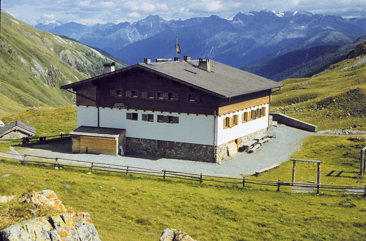
Kurz danach erreicht man die Sesvenna Hütte auf 2256 m Höhe (1,5 - 2 Std. von Schlinig). Die gemütliche und gut bewirtschaftete Sesvennahütte (2256 m - rechtes Bild) bietet Lager und Zimmer mit Etagendusche, sowie Zimmer mit Dusche und ist Ausgangspunkt zahlreicher Wander- und Skitouren immer mit Blick auf die Gletschergipfel der Ortlergruppe.
The much more comfortable and well-managed Sesvenna Hut (2256 m) is just a few minutes away (1.5 - 2 hours from Schlinig) and offers dormitories with showers on the same floor and even rooms including showers. It is a starting point for quite a few hikes and ski tours in a beautiful landscape with the glaciated summits of the Ortler Range always present.
Uina Schlucht / Uina Canyon
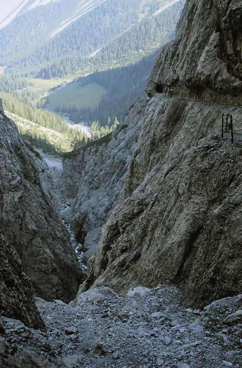
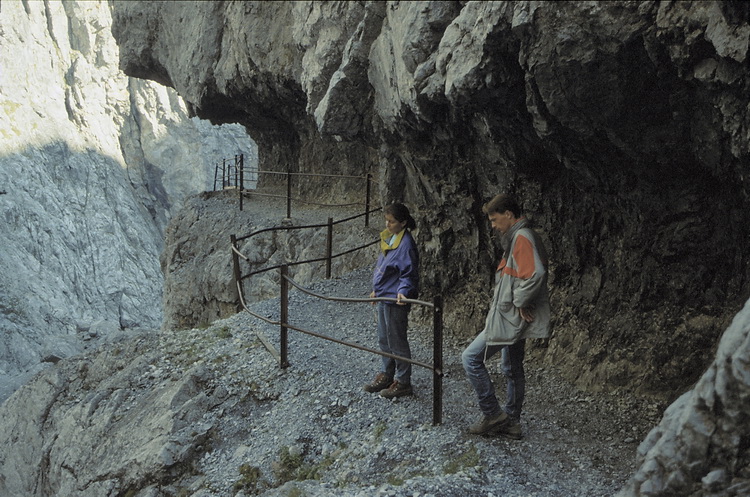 Vom Schlinigpass nordwärts frisst sich ein Bach nach wenigen Kilometern durch die wilde Uinaschlucht. Eine Stunde von der Sesvennahütte. A brook that flows down from the Schlinig Pass in northern direction has formed the Uina Canyon which is worth to be visited (about one hour from the Sesvenna Hut). |
 |
Schadler / Piz Rims / Piz Cristanas
Die Tour über Schadler und Piz Rims zum Piz Cristanas ist ein durchgehender Weg und bietet keine klettertechnischen Schwierigkeiten, trotzdem muss an die objektiven Gefahren einer Hochtour (Akklimatisation, Kondition, Wetter, Kälte, Wind usw.) gedacht werden. Erstes Ziel ist das Sesvennajoch (2801m), etwa eine Gehstunde südwestlich der Sesvennahütte. Vom Sesvennajoch (2801 m) führt nordwestwärts eine Wegspur auf den Schadler (2948 m) mit prächtigem Blick zum Piz Sesvenna (etwa 0,5 Stunden vom Sesvennajoch).
The traverse of Schadler, Piz Rims and Piz Christanas does not show real climbing difficulties as there is a path on the whole hike. Nevertheless the objective dangers of a high alpine tour must be considered (acclimatisation, fitness, weather, protection from coldness and wind). Our first aim is the Sesvenna Saddle (2801 m) about one hour south-west of the hut. Following the track that leads in north-western direction it takes about half an hour get to the summit of Schadler (2948 m) with its nice panorama of Piz Sesvenna.
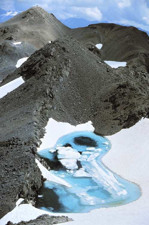
Mit wenigen Metern Abstieg vom Schadler führt der Weg weiter (im Bild von links nach rechts) zum Piz Rims links im Hintergrund (3051 m - ca. 0,5 Stunden vom Schadler), vorbei am Gipfeleissee des Piz Cristanas
After a short descent from Schadler it takes another half an hour to get to Piz Rims (3051 m - left in the background) which we traverse in direction to Piz Cristanas (another 0.5 hours) and its ice lake.
 |
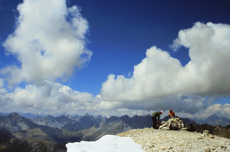
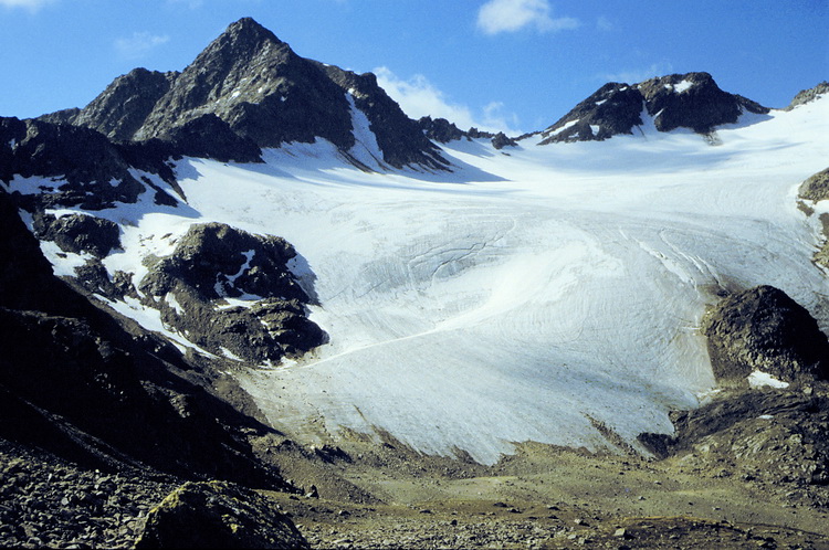
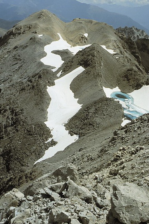
Blick vom Gipfel des Piz Cristanas über die Karstlandschaft zum Piz Lischanna. Am Gipfel der Piz Cristanas (3092 m) mit Blick zum Piz Sasura links des Gipfelsteinmanns mit dem Sasuragletscher und dem Piz Linard rechts im Hintergrund. View from the top of Piz Cristanas across a karst scenery to Piz Lischanna. The summit of Piz Cristanas (3092 m) with Piz Sasura and the Sasura Glacier left of the summit and Piz Linard behind to the right. |
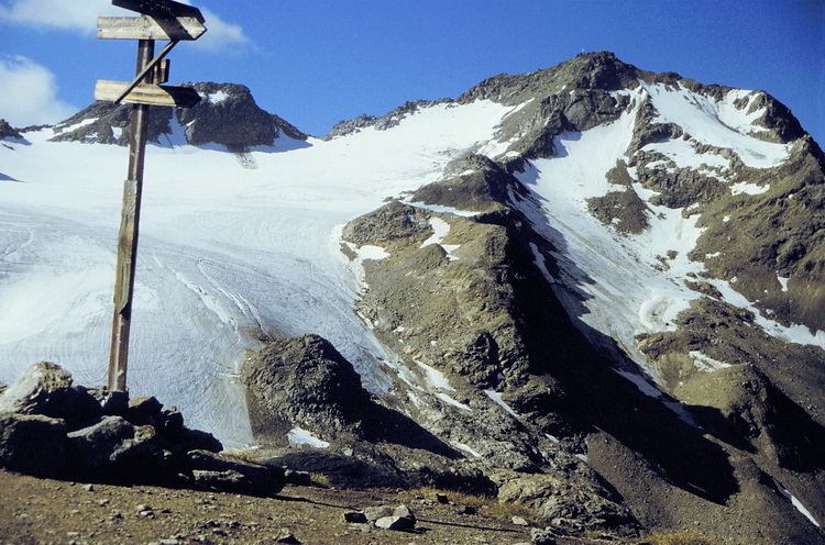
Rasass Spitze (2941 m)
 |
Ein gut markierter Weg führt auf den Hausberg nördlich der Sesvenna Hütte. Hinter der verfallenen Rasasshütte erkennt man das Ortler Massiv mit Zufallspitze, Cevedale, Königsspitze und Ortler. Der Weg im Vordergrund führt über den flachen Schlinigpass (2309 m) zur sehenswerten Uinaschlucht, die schon auf schweizer Boden liegt. Durch die Schlucht gelangt man ins Unterengadin. A well marked path leads to the summit of Rasass Spitze (2941 m) north of the hut. Behind the decayed Rasass Hut the Ortler Range is dominating with Zufallspitze, Cevedale, Königsspitze and Ortler. The path in the foreground leads across the flat Schlinig Pass (2309 m) to the Uina Canyon and further into the Lower Engadine area in Switzerland. |
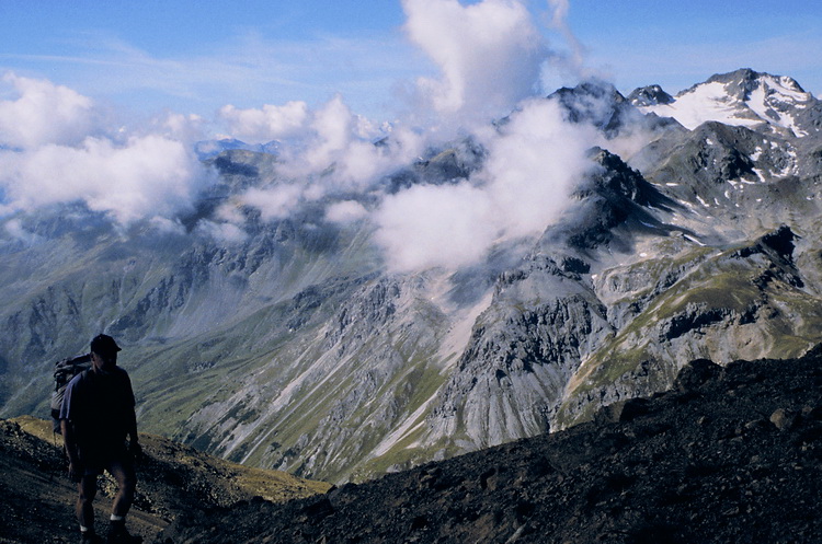
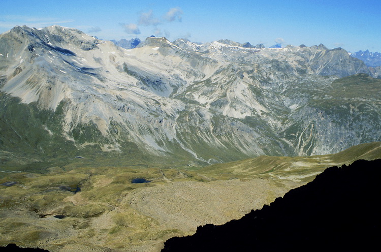
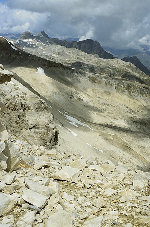
Kurz vor dem Gipfel der Rasass Spitze (2941 m) mit Blick nach Südwesten zum vergletscherten Piz Sesvenna (3205 m). Der dunkle Berg im Mittelgrund rechts etwas unterhalb der Wolke in Bildmitte ist der schon erwähnte Föllerkopf (2878 m). Darüber der Muntpitschen (3162 m) teilweise im Nebel. Der Blick westwärts zeigt links die von der Sesvennahütte einfach zu ersteigenden Dreitausender Piz Rims und Piz Cristanas und in Bildmitte der Piz d' Immez. Rechts dahinter zeigen sich die Engadiner Dolomiten um den Piz Lischanna.
Just below the summit of Rasass Spitze (2941 m) looking in south-western direction towards the partly glaciated Piz Sesvenna (3205 m). The dark summit in the middle just below the cloud is Föllerkopf (2878 m) with Muntpitschen (3162 m) behind. The panorama in western direction shows the easy to climb 3000 meter peaks Piz Rims and Piz Cristanas as well as Piz d' Immez in the center. Continuing to the right we can see Piz Lischanna and the surrounding so-called 'Engadine Dolomites'.