Das Karakorum im Überblick
Im Norden Pakistans (genannt Northern Areas) liegt der sogenannte Pamirknoten, wo drei Erdplatten zusammenstoßen - die Indische Platte im Süden mit dem Himalaya und dem Nanga Parbat, die Arabische Platte mit dem Hindukusch im Westen und die Eurasische Platte mit dem Karakorum, Pamir, Tienschan und dem Transhimalaya im Norden. Die Subduktion der Indischen Platte unter die Eurasische Platte erfolgt mit einer Geschwindigkeit von etwa 3 cm pro Jahr was zur Folge hat, dass das Karakorum bezüglich der Durchschnittshöhe das höchste Gebirge der Erde ist.
Knapp 140 Karakorumgipfel in Pakistan sind über 7000 m hoch und 5 Gletscher über 50 km lang. Die aussergewöhnliche Höhe des Nanga Parbat (8125 m) in einem wesentlich niedrigeren Teil des Himalaya könnte einen anderen Grund zu haben: Die enorme Masse des vom Indus abtransportierten Erosionsmaterials bewirkt eine Verminderung des gravitativen Drucks in dieser Region, welche das Nanga Parbat Massiv anhebt. Der gleiche Mechanismus, verursacht durch den Tsangpo (Brahmaputra), hebt vermutlich im östlichen Himalaya den Namcha Barwa (7782 m), welcher alle Gipfel jener Region überragt.
Das Klima des Karakorums wird im Winterhalbjahr vom polaren Jetstream bestimmt, während der Sommermonsun nur sporadisch auftritt. Nur im hohen Karakorum erreichen feuchte Luftmassen das Gebirge über die niedrigen Berge des Himalaya und bringen dort viel Schnee. Die Vergletscherung des Karakorums (wörtlich: 'schwarzes Geröll') beträgt etwa 25%, deshalb werden die hohen Bergketten auch 'Muztagh' (Schneeberge) benannt.
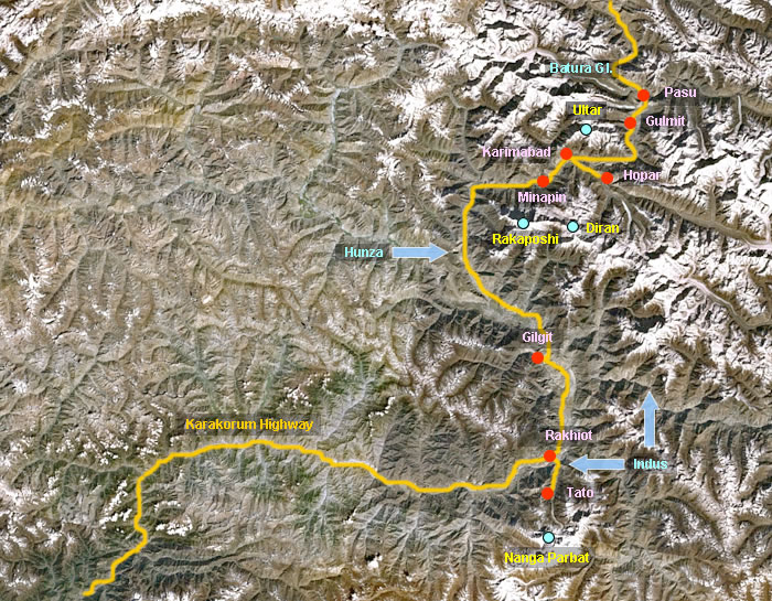
Die Bilder auf den folgenden Seiten entstanden in den Jahren 1981 und 2007. Wir folgen hierbei dem Karakorum Highway durch das Industal bis zu unserem ersten Ziel: der Märchenwiese am der Nordseite des Nanga Parbat. Kurz vor Gilgit verläßt der Highway das Industal und führt den Hunzafluß entlang über Karimabad über den Khunjerab Pass nach China. Im Gegensatz zum wüstenhaften Industal ist das Hunzatal eine Oase mit grünen Feldern und Obstgärten, die durch ein ausgeklügeltes Bewässerungssystem gespeist werden. Hier gedeihen alleine 3 Dutzend verschiedene Aprikosensorten, genügend Getreide, Obst und Gemüse um den Hunzukuts ein autarkes Leben über Jahrhunderte zu gewährleisten. Eine faszinierende Landschaft mit faszinierenden Menschen und zahlreichen Möglichkeiten für eindrucksvolle Wanderungen.
The pictures on the following pages were taken during two different trekking tours in 1981 and 2007. We follow the Karakoram Highway along the Indus River until to our first stop: Fairy Meadows near Tato below the north face of Nanga Parbat. Just before Gilgit the highway is leaving the Indus Valley now following the Hunza River to Karimabad, the Khunjerab Pass and finally the Chinese border. Compared to the desert-like Indus Valley the Hunza Valley is an oasis with green fields and orchards due to a sophisticated irrigation system. Here we find about 3 dozen sorts of apricots, enough grain, food and vegetables to ensure the Hunzukuts a self-sufficient life for centuries. A fascinating scenery with fascinating people and numerous possibilities for impressive hikes.
The 'Pamir Knot' in the northern part of Pakistan is a place where 3 plates of the earths crust are drifting towards each other. These are the Indian Plate with Himalaya and Nanga Parbat in the south, the Arabian Plate carrying the Hindukush mountains in the west and the Eurasian Plate with Karakoram, Pamir, Tienshan and the Transhimalaya Range in the north. The Indian Plate is drifting below the Eurasian Plate at a speed of approximately 3 cm a year. This is the reason for the Karakoram being the worlds' highest mountain range with regard to its average altitude.
About 140 peaks are higher than 7000 m and 5 glaciers are longer than 50 kms. The exceptional height of Nanga Parbat (8125 m) however could possibly be due to another reason: The enormous mass of debris which the Indus River is transporting leads to a reduction of the gravitative pressure with the result that the Nanga Parbat massive is raised. The same phenomenon seems to be responsible for the lifting of Namche Barwa (7782 m) in the eastern Himalaya by the Tsangpo (Brahmaputra) River, a peak which is also towering high above the other peaks in this area.
The climate of the Karakoram Range in winter is determined by the polar jet whereas the summer monsoon is only appearing sporadically. Only in the high mountains of the Karakoram are reached by the humid air masses resulting in heavy snowfalls in these areas. The glaciation of the Karakoram (meaning 'black debris') is only 25 % and due to this the high mountains are called 'Muztagh' which means snow mountains.