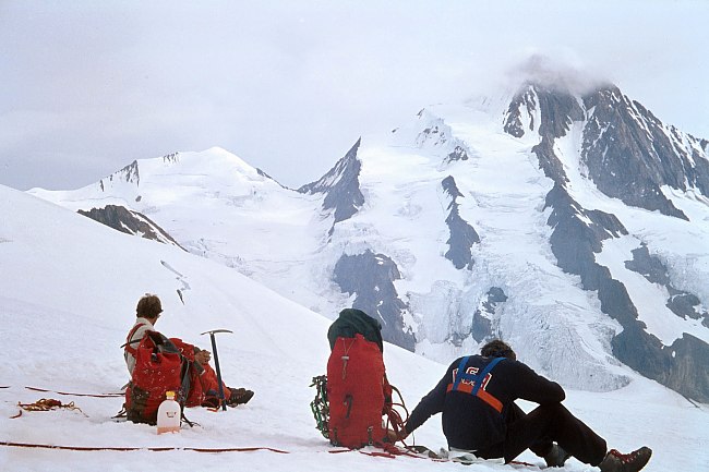
Berner Oberland: Finsteraarhorn (1980)
Startpunkt dieser Rundtour ist Fiesch im Rhonetal. Über das Eggishorn und den Aletschgletscher erreicht man am ersten Tag die Konkordiahütten um am nächsten Tag über die Grünhornlücke zur Finsteraarhütte zu gelangen. Nach der Besteigung des Finsteraarhorns über Westflanke und Hugisattel folgt dann am vierten Tag der Abstieg über den Fieschergletscher zurück zum Ausgangspunkt.
We started this tour on the summit of Eggishorn high above the town of Fiesch in the Rhone Valley. Following the Aletsch Glacier we and finally reached the Konkordia Huts where we spent our first night. On the next day we traversed the Grünhorn Pass to get to get to the Finsteraarhorn Hut, the basis to climb Finsteraarhorn via its west-face. The Fiescher Glacier brought us back to Fiesch.
Der erste Blick auf das Finsteraarhorn vom Furkapass.
First view of Finsteraarhorn from the Furka Pass.
 |
Der Große Aletschgletscher von der Riederalp. Im Hintergrund die Wannenhörner. Unterhalb der tiefsten Einsattelung im rechten Bildteil führt der Weg von der Märjelenalp auf den Aletschgletscher. The Aletsch Glacier seen from the Riederalp with Wannenhörner in the background. The glacier is entered just below the lowest gap in the right part of the picture. |
 |
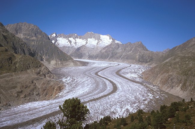
Der Aletschgletscher mit Konkordiaplatz vom Gipfel des Eggishorns (2927 m), dahinter Jungfrau (4158 m), Mönch (4099 m), Trugberg (3932 m) und Eiger (3970 m - dunkler Felsgipfel). Aletschgletscher and Konkordiaplatz from the summit of Eggishorn (2927 m). In the background Jungfrau (4158 m), Mönch (4099 m), Trugberg (3932 m) and Eiger (3970 m -the rock summit to the right). |
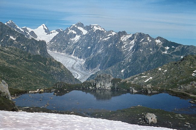
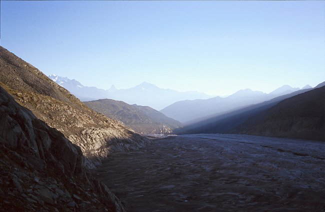
See auf der Alp Märjela, nördlich des Eggishorns. Blick nach Osten auf den Fieschergletscher über den der Rückweg führt. Ein weiterer See befindet sich auf der Märjelenalp kurz vor dem Übergang auf den Aletschgletscher. Der berühmte Gletschersee existierte 1980 nicht.
Lake on the Alp Märjela north of the Eggishorn. View to the east towards the Fiescher Glacier which is traversed on the way back to the starting point. Another Lake is situated on the Märjelenalp just before we entered the Aletsch Glacier. The well known glacier lake didn't exist in 1980.
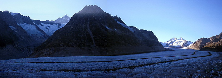
Wie eine Autobahn zieht sich der Aletschgletscher zum Konkordiaplatz hinauf, der noch in der Sonne liegt. Im Hintergrund das Jungfraujoch, rechts davon der Mönch (4099m) und der Trugberg (3932m).
Like a motorway the Aletsch Glacier leads up to the Konkordiaplatz which is still lying in the sunshine. Behind Jungfraujoch, to the right Mönch (4099 m) and Trugberg (3932 m).
 |
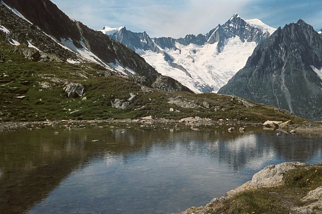
Blick vom Aletschgletscher auf die Walliser Berge, von links nach rechts Dom - Matterhorn - Weisshorn. View from the Aletsch Glacier to Wallis mountains, from left to right Dom - Matterhorn - Weisshorn. |
 |
Der Aufstieg zur Grünhornlücke (3286 m). Über die unteren Felsen in Bildmitte vor dem Konkordiaplatz führen Leitern zur Konkordiahütte. Hinter dem Dreieckshorn das Aletschhorn mit der Haslerrippe zwischen den beiden Felsgraten. Ascending the Grünhorn Pass (3286 m). The lower part of the rocks on the left side are traversed on ladders leading to the Konkordia Huts. In the background Dreieckshorn and Aletschhorn with the Hasler Rib between the two rock ridges. |
 |
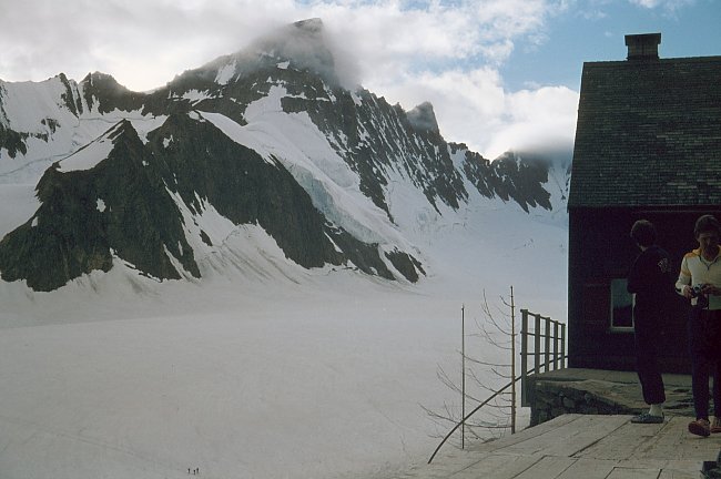
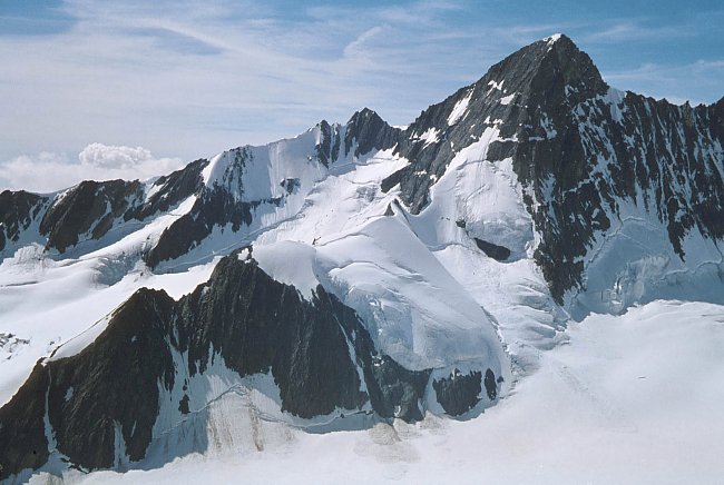
Grünhornlücke Blick nach Osten zum Finsteraarhorn (4274 m). Links das Agassizhorn (3953 m), in Wolken der Hugisattel (4088 m) gefolgt vom Nordwestgrat über den der Normalanstieg zum Finsteraarhorn führt. View to the east to Finsteraarhorn (4274 m), left the Agassizhorn (3953 m). In the clouds the Hugi saddle (4088 m) continued by the north-west ridge which is the standard ascent route. |
 |
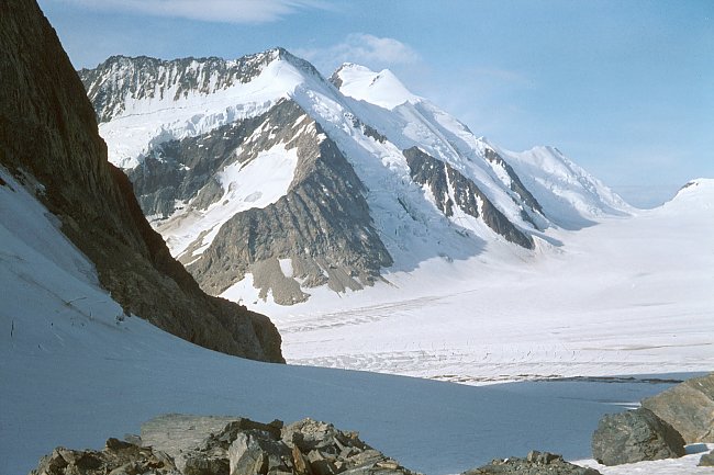
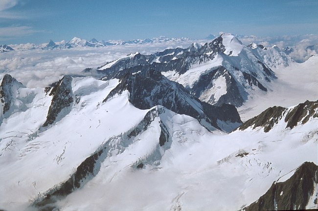
Blick von der Finsteraarhornhütte (3048 m) über den Fieschergletscher nach Nordwesten zum Grünegghorn (3860 m), Grossgrünhorn (4044 m) und Kleingrünhorn (3913 m). View from the Finsteraarhorn Hut across the Fiescher Glacier in north-western direction to Grünegghorn (3860 m), Grossgrünhorn (4044 m) and Kleingrünhorn (3913 m). |
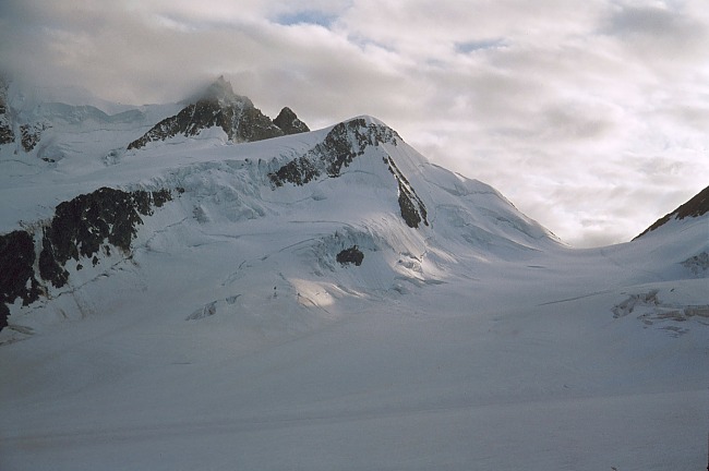 |
Nach Westen die Grünhornlücke. Von dort nach links ansteigend: Wysnollen (3595 m), Chamm (3866 m), Fiescher Gabelhorn (3876 m), Schönbielhorn (3854 m, in Wolken). Grünhornlücke to the west. From there ascending to the left Wysnollen (3595 m), Chamm (3866 m), Fiescher Gabelhorn (3876 m), Schönbielhorn (3854 m - in the clouds). |
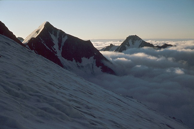 |
Aufstieg zum Finsteraarhorn (Normalweg) Blick nach Südosten zum Finsteraarrothorn (3530 m) und Wasenhorn (3447 m) rechts. On the Finsteraarhorn standard ascent route. South-eastern view to Finsteraarrothorn (3530 m) and Wasenhorn (3447 m) to the right. |
 |
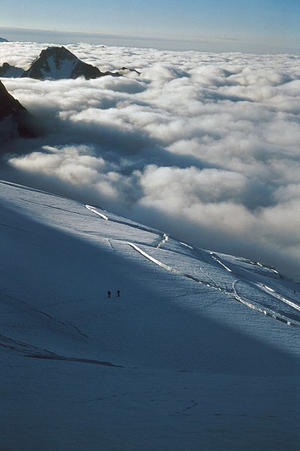
Blick auf das Grosse Wannenhorn (3905 m). Der Normalweg und die Skiroute verlaufen diagonal von links nach rechts. View to 'Grosses Wannenhorn' (3905 m) which is climbed diagonally from left to right. |
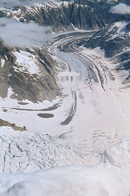
Aufstieg zum Finsteraarhorn nahe Punkt 3616 m, wo man ein Fels- und Schuttband überquert, um auf den Gletscher zu gelangen, der sich zum Hugisattel hinaufzieht. Unterhalb der Finsteraarhorn Ostwand der Finsteraargletscher. Von links mündet der Strahlegggletscher ein, weiter im Hintergrund ebenfalls von links der Lauteraargletscher.
Near point 3616 m where a rocky band has to be crossed to reach the glacier leading to the Hugi Saddle. Looking down the east face of Finsteraarhorn we could see the Finsteraar Glacier. From the left side the Strahlegg Glacier is joining as well as the Lauteraar Glacier in the background.
 |
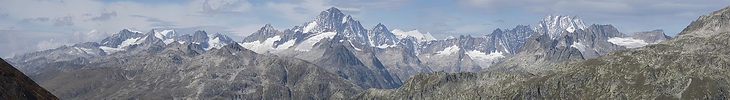
Im Vordergrund rechts die Grünhornlücke. Jenseits des Rhonetals Matterhorn, Weisshorn, Dent Blanche, weiter rechts der Grand Combin. Direkt über dem Aletschhorn der Mont Blanc. In the foreground - to the right - the Grünhorn Pass. Beyond the Rhone valley Matterhorn, Weisshorn, Dent Blanche and Grand Combin. Just above the Aletschhorn the Mont Blanc. |
 |
Blick nach Norden zum Schreckhorn (4078 m, links) und Lauteraarhorn (4042 m). View to the north with Schreckhorn (4078 m, left) and Lauteraarhorn (4042 m). |
 |
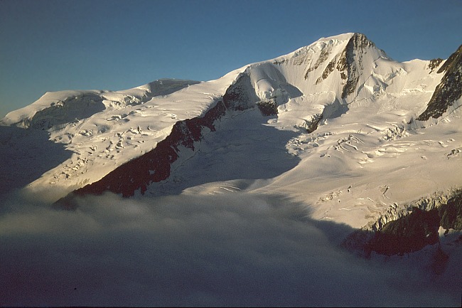
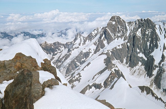
Abstieg vom Finsteraarhorn: Grünegghorn (3860 m) und Gross Grünhorn (4044 m). Descent from Finsteraarhorn with Grünegghorn (3860 m) and Gross Grünhorn (4044 m). |